Samoa is made up of two main islands, Upolu and Savaii (you pronounce Savaii like you pronounce Hawaii). Upolu is where the capital is, and where most people live. It is about 70 kms from east to west, and about 30 kms wide. The islands have some rare wood pigeons and flying foxes, and plenty of species of native rainforest trees still growing up in the mountains. The pigeons act as the dispersal agents for the seeds of some of these rainforest trees, so if the pigeons go (and they are hunted for food), the trees will go. If the trees go the pigeons will lose their nesting places and food sources, so they will go.
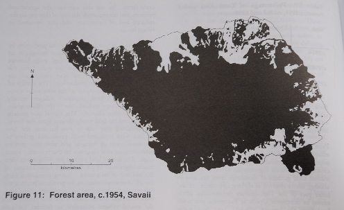
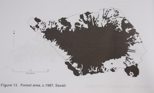
Although this island has green everywhere you look, nature does have some troubles. The four pictures below (from Samoa: Mapping the Diversity, R. Gerard Ward and Paul Ashcroft, Suva: University of the South Pacific 1998) show how much forest has been chopped down in the last fifty or so years. The centre of both the islands is full of mountains, and it is for this reason that the forest remains in the centre of the islands. These uplands have a much higher rainfall, lower hours of sunshine and temperature, steeper slopes and poorer soils than the lowlands. So like many places in the world, nature hangs out and hangs on where the ground is too steep for humans to grow stuff on it.
The two pictures below are of the main island – home to the capital and where most Samoans live. Witness the even greater change between the fifties and the eighties on Upolu.
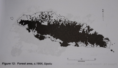
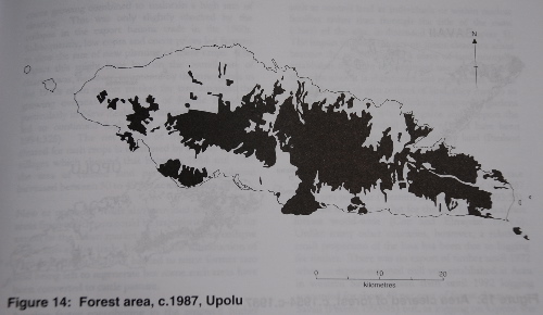
From the mid 1950s to the late 1980s the amount of forest on Samoa went from 74 per cent of its land area to 55 per cent. Before Europeans arrived here the population was stable and forest regeneration was allowed to happen as they moved their root crops from one area to another. Then along come the white folks…
The Germans and then the Kiwis encouraged the expansion of cash crop production: coconuts, cocoa and bananas. This combined with the clearing places on the edge of the forest to plant taro, and a rising population from the 1920s onwards, saw the forest retreat. New roads now aided the clearing of the land for agriculture. The high rate of clearing slumped a little when there was a collapse in the export trade of bananas in the 1960s. But then by the 1970s there were Samoans living in New Zealand and Samoa started exporting taro for their taste preferences overseas, and this continued the high rate of clearing. The introduction of the Taro Leaf Blight in 1993 destroyed this export trade, and some former taro growing land has regenerated.
Then there was the change in tenure practices. Land was traditionally controlled through the title of the matai (chief), but more and more people have tried to control land as individuals. The act of clearing a bit of land traditionally gave you ownership of it, so people have tried to clear land to get land for themselves.
So on Samoa in the late 1980s forest loss was 2 per cent per year – about the same rate as the loss of tropical rainforests worldwide. Unlike other parts of the world, only a small amount of this loss comes from logging for timber. There has been some, but by 1992 only 14 per cent of the primary forest on Savaii was suitable for logging, and there was none left on Upolu.
So you have to hand it to the champions of Western civilization. Sure there are some sealed roads on the island now, and some hydro-generated electricity, both good things. But the West can be proud at having brought Samoa export trades and a dash of selfish individualism which in combination have gradually skinned the lowlands of their nation. I was hoping to be able to walk around some flat, lowland rainforest with big old trees, but that isn’t too easy nowadays.